
My Work
When appropriating a “starter” stack from a company like ESRI, some features are built-in but require customizations and comfort with the coding best practices dictated by a new framework. My contributions included:
- Readable, maintainable and modular JavaScript. This was essential for an effort that likely would find its way to different development team over a period of years.
- Easy, intuitive design. Developing a comprehensive help documentation and retrofitting special user experience ehancements outside of ArcGIS and Dojo defaults.
Synopsis
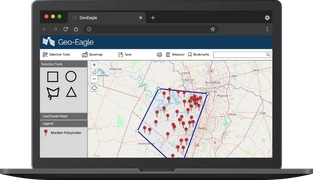
When you have a nationwide customer base of millions of homeowner’s insurance policies you can sometimes get only a myopic view from charts and spreadsheets. This project sought to do three things:
- Allow MSRs (Member Service Representatives) to select areas on a map and retreive all relevant homeowner policies.
- Allow MSRs and executives to overlay weather, fire, and other maps and measure proximity to potentially catastrophic events.
- Allow MSRs to export emails and contact information for aggregate warnings or instructions to policy owners.
Technology Stack
We utilized services from ESRI, a company that builds and maintains a mapping and spatial analytics product called ArcGIS. Through their licensing, we were able to house a replica of our own confidential data on an in-house server.
The front-end part of the stack is built on Dojo Toolkit, an open- source modular JavaScript library. The stack incorporates modern ECMAScript features such as client-side storage for better memory management of large data-sets.